Directions:
From Dublin, approach from Oldbawn, Tallaght,
towards Bohernabreana, taking the Brittas road to the
stone cross. Orienteering will be sign posted from here.
An
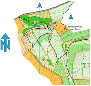
extract of Setanta's map of Ballinscorney
The
Ballinascorney map takes in Ballinascorney wood, Black
Hill, Seahan and some surrounding areas. The area was first
used for orienteering in 1979 when Setanta Orienteers organised
one of the first Leinster Championships. The area was used extensively
for a number of years subsequently before Coillte felled large
areas of mature forest. The area was re surveyed a number of years ago.
It now has limited use as large areas are difficult to run on and is used
mainly for training and local events