Home Results Fixtures Rogaine Information about Setanta Orienteers Images of Setanta's maps Tales from the Undergrowth Orienteering related links Contact information
 
Djouce Woods, Enniskerry, County Wicklow
Hellfire Club, Killakee
Killakee, County Dublin
Mullaghmeen, Castlepollard, County Westmeath            
Glendasan, Laragh, County Wicklow
Ballinascorney, County Dublin          
Glen of the Downs and Kindlestown Woods, Kilmacanogue, County Wicklow                      
Croghan Kinsella, Woodenbridge, County Wicklow                      
Other maps                      
                     
 
The Hell Fire Club sits atop Montpelier Hill

Directions: This area is close to Dublin City, being only a few kilometres south of Rathfarnham and east of Tallaght. From Ballyboden or Knocklyon, approach via Scholarstown Road and Stocking Lane. From Oldbawn, approach via Oldcourt Road.

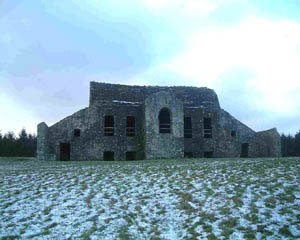
The ruin of the Hell Fire Club sits on the top of Montpellier Hill and can be seen over a wide area of the city. You can read more about the Hell Fire Club here. The Hell Fire Wood is named after this ruin and is a mainly coniferous forest owned by Coillte, the state owned forestry company.

Massys Estate is a deciduous wood across the Killakee Road from the entrance to the Hell Fire Wood. It contains the ruined formal gardens and other remnants of Lord Massys House (now demolished). The wood is also owned by Coillte and is popular for walking and exploring the mature woodland landscape.

An extract from Setanta's map of Hellfire Wood and Massy's Estate
 
The first map of the area was produced by Setanta Orienteers in 1982. This was a small map and included Massys Estate and the part of the Hell Fire Wood only as far as the Hell Fire Club. Future revisions included the entire Hell Fire Wood west of the club ruins. In recent times, separate maps have also been produced of Massys Estate and the Hell Fire Wood. It continues to be a most popular orienteering venue.