Orienteering
in Glendasan
Directions:
approach from Laragh to the East. Travel in direction
of Glendalough taking the Wicklow Gap road. Alternatively
it may be approached from West Wicklow by taking the Wicklow
Gap road. The area is south east of the Turlough Hill
power generating station.
Glendasan was first used for orienteering for the Setanta Orienteers 2004 Leinster Championships. The Camaderry area had been identified for some time as being interesting terrain for orienteering, but physical and difficult to map. Having the benefit of a Stirling Surveys plot Setanta Orienteers decided in 2003 to produce a map of the area now known as Glendasan. This is the name of the valley and river that flows through it. The map also covers part of the Brockagh Mountain side of the valley. Glendasan is part of the Wicklow Mountains National Park.
Glendasan was first used for orienteering for the Setanta Orienteers 2004 Leinster Championships. The Camaderry area had been identified for some time as being interesting terrain for orienteering, but physical and difficult to map. Having the benefit of a Stirling Surveys plot Setanta Orienteers decided in 2003 to produce a map of the area now known as Glendasan. This is the name of the valley and river that flows through it. The map also covers part of the Brockagh Mountain side of the valley. Glendasan is part of the Wicklow Mountains National Park.
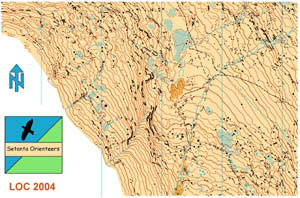
An
extract of Setanta's map of Glendasan
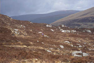
The
Glendasan valley has some interesting history and is the site
of numerous old mine workings from another era. The terrain is entirely
open moorland with some steep and rocky terrain. The orienteering map
is very detailed and accurately reflects the difficult nature of the ground.
The orienteering is physical and challenging. The map scale is 1:7500
to improve overall legibility. The map will be further extended over the
next year to be used for a major regional event.