Directions:
From Enniskerry proceed past Powerscourt House toward
Powerscourt Waterfall. Orienteering events may start at Crone
car park or from the Long Hill car parks on the road to Roundwood.
There will be local sign posting.
Djouce Woods are located on the northern side of Djouce mountain with the Powerscourt Waterfall at its centre. The area is quite extensive and includes the coniferous woods to the east of the waterfall grounds and deciduous woodlands to the west. Part of Crone Woods and open ground southeast of Maulin and Djouce mountains are also included.
Djouce Woods are located on the northern side of Djouce mountain with the Powerscourt Waterfall at its centre. The area is quite extensive and includes the coniferous woods to the east of the waterfall grounds and deciduous woodlands to the west. Part of Crone Woods and open ground southeast of Maulin and Djouce mountains are also included.
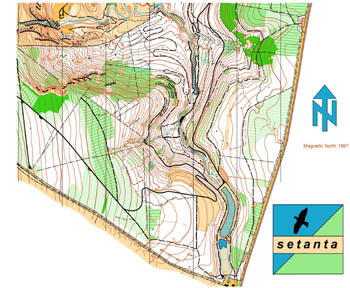
An
extract of Setanta's map of Djouce Woods
The
map was produced in 1997 for the Leinster Championships that
year and has been used a number of times each year since then. It has
some good orienteering terrain although parts are quite steep. The area
has “survived” well having avoided extensive felling, except
for the Crone area. The forestry is owned by Coillte
while the waterfall area is part of the Powerscourt Estate (restricted
access).